
Interactive map predicts farming decline from climate change by end of century
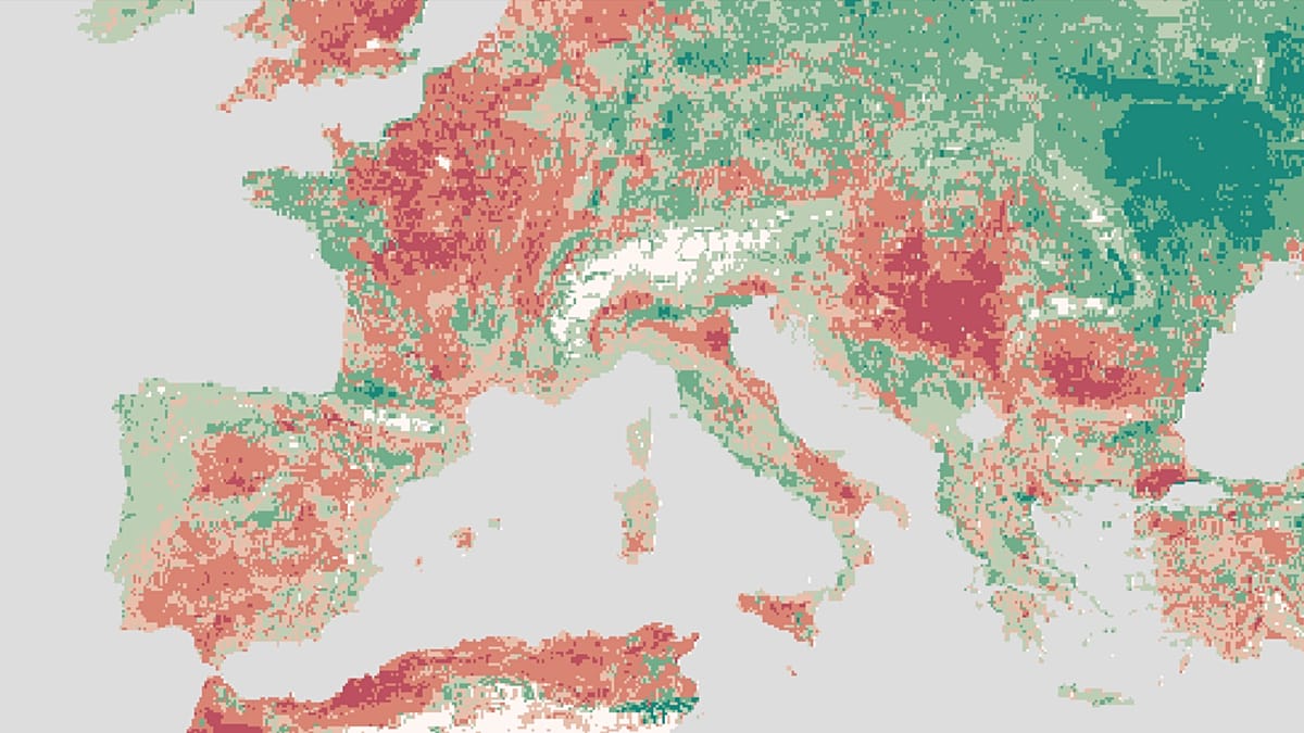
A CSIC team in Barcelona has developed CADI, a platform that, on a 10‑kilometre grid, estimates how much farmland will lose productivity to climate change by 2100. In Spain, inland areas fare worse than the Cantabrian coast.
A team from the Institute for Economic Analysis (IAE), a centre under Spain’s National Research Council (CSIC), has developed a tool that can predict, with a precision of 9.3 x 9.3 kilometres, how the planet will gradually lose its capacity to produce food as climate change advances.
It is called CADI, which in English stands for Climate-induced Agricultural Decline Index, and its purpose is easy to describe, though not to calculate: to compare how much a given plot of land could yield under different climate conditions, keeping the crops grown in 2020 fixed. This isolates the pure effect of climate, without mixing it with human decisions about what to plant or how to adapt.
How the model works
The platform (CADI (source in Spanish)), coordinated by Laura Mayoral and Hannes Mueller, who are also affiliated with the Barcelona School of Economics, has been developed with the collaboration of the Centre for Economic Policy Research, the UK Foreign Office and an initiative focused on conflicts stemming from economic crises.
The starting point is two data sources: historical crop yields from the FAO and climate records from the EU’s Copernicus programme. Using these, the team reconstructs what changed between 1981-2000 and 2001-2020 and then projects, under the different scenarios used by the IPCC, how that same variable will evolve through to the end of the century.
The premise, which is crucial for interpreting the results, is that no adaptation measures are assumed: the idea is to see what would happen if everything stayed the same except the climate.
Winners and losers, including within Spain
The data already observed, not projected, show that one in six plots of cropland worldwide has lost more than 10% of its potential productivity in the last two decades compared with the previous two.
The distribution of these losses is highly uneven: the tropics bear most of the damage, while some high-latitude areas gain ground, although they start from production levels so low that the percentage increase barely translates into more real calories.
In Europe, the familiar north-south pattern is repeated: Scandinavia, Scotland and the Alps gain agricultural potential, while the south of the continent loses it.
Spain is no exception to that rule, but it is not uniform internally either.
As Mueller explains, the Cantabrian coast, Galicia and the Pyrenees gain productivity, while much of the interior and the central-eastern part of the peninsula declines, with pockets of particularly severe losses. In a way, it is the same imbalance seen at planetary scale, but reproduced within the country’s borders.
What it means for the next generation
Right now, 15% of the world’s population already lives in areas where agricultural potential has fallen by at least 5%. If warming follows a medium-high trajectory, around a further 2.1ºC between now and mid-century, that figure could soar to almost half of the planet’s inhabitants between 2041 and 2060.
The model also points to a very marked concentration of the problem: just 5% of tropical land already accounts for 35% of all recorded losses, and only a quarter of countries are expected to shoulder 85-90% of global damage by mid-century.
The researchers stress a nuance that is often overlooked: even where productivity rises, tensions emerge. Gains force land, water and investment to be diverted to new areas within the same country, which can generate frictions between regions that until now were not competing for those resources.
On top of that comes a deep injustice highlighted by the study: the countries that have emitted the least greenhouse gases over history are among the most exposed to these losses, and that gap is set to widen.
For the authors, CADI’s value lies not only in its diagnosis but also in its practical use:
- It makes it possible to identify in advance which areas will need support to adapt
- New crops
- Technology
- Relocating production
- Channelling resources before falling yields translate into lower rural incomes, greater food insecurity or population movements forced by a lack of alternatives. You can visit the project here (source in Spanish) and see the two types of projections, produced in 20-year steps from 2020 to 2100, showing how agricultural output evolves by region as the climate advances.